
Mandalay-Amarapura
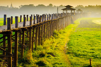
Situated not far from Mandalay it was also one of the capital cities of the last Konbaung Dynasty. Amarapura was the capital during the reign of King Bodawpaya from 1783 A.D to 1819 A.D. The U Bein Bridge that spans the TaungTha Man Lake is the most popular site for tourists here. This teak bridge is nearly a mile long and more than a century old and named after its donor U Bein, who was the mayor of the town. On the other side of the lake is the TaungTha Man Kyauk Taw Gyi Image, a huge Buddha hewn out of a single block of marble. The famous Maha Gan Da Yone Monastery is also situated not very far away. It is one of the most illustrious learning centers of Buddhist scripture for the monks.
Inwa
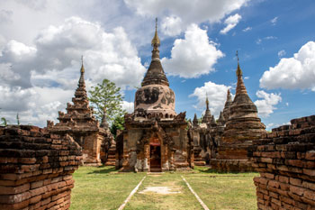
The Pali name of this city is Ratanapura or the City of Gems. Innwa was first made a capital in 1364 A.D by King Thado Min Bya but attained its magnificence under the Konbaung Dynasty only. King AlaungPaya, who founded this dynasty made Shwebo his capital but his son, King HsinByu Shin (Lord of the White Elephant) who succeeded him moved to Innwa in 1763 A.D. Innwa is now a quiet small village but many ruins dating from the King's time are still visible. The most remarkable sites are the Watch Tower, partially destroyed in an earthquake and the Mei Nu Oak Kyaung or the Brick Monastery of Queen Mei Nu, one of the very powerful queen of that time and donated to the Chief Abbot and the Bagaya Teak Monastery.
Mandalay-Sagaing
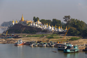
After the Bagan Kingdom was destroyed there appeared other short lived kingdoms; Pinya and Sagaing. Athin Ga Ra Saw Yun, a prince of one of the royal houses, established the Nyaung Yan Dynasty and made Sagaing the capital but it lasted only a scant 40 years and had 7 rulers. Sagaing is famous for its Sagaing Hills, the numerous monasteries and nunneries and the nearby dome-shaped KhaungHmuDaw Pagoda. The Innwa Bridge that spans the Ayeyarwady river at this point was destroyed by the retreating British forces in WWII but was rebuilt. Thabyedan Fort, on the Amarapura side of the river and beside the bridge, was used by the Myanmar Imperial Army to guard against the advancing British forces.
Mandalay-Pyin Oo Lwin
42 miles from Mandalay and accessible by car is the beautiful town of Pyin Oo Lwin. Previously it was known as Maymyo in honour of Col. May of the 5th Bengal Infantry who was stationed there in 1886 A.D. Pyin Oo Lwin is situated on the Shan Plateau at the elevation of above 3500 feet and as such enjoys a very pleasant and cool climate. The British Colonial Government designated this town as the Summer Headquarters and consequently there are many small bungalows set in spacious and flowering gardens in the best English country house styles. The Botanical Gardens have now been up-graded into a National Kandawgyi Gardens. Pyin Oo Lwin is also on the Burma Road which gained fame during the 2nd World War.
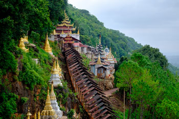
Heho-Pindaya
This is also an old town once governed by a ngwekunhmu or a collector of taxes during its feudal period. There is a cave high up on a cliff where legend say lived a huge spider and a virgin is sacrificed everyday until a prince came along and shot it. Now this lime stone cave is filled with tens of Buddha Images and pagodas of all sizes. The lake in the middle of the town is said to be the place where the mythical half-human and half-bird Keinnari girls bathe. Trekkers can go to many surrounding Pa O, Palaung and Danu villages around Pindaya.
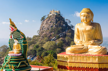
Mt.Popa
Approximately 40 miles from Bagan towards the east is the famous Mt. Popa known as the Mt. Olympus of Myanmar. The mountain is an extinct volcano and nearby is the pagoda studded smaller peak. Popa region is a geographical phenomenon, a green and cool oasis with many exotic herbs and flowers in the centre of a dry and dusty Myingyan Plain. Due to this extraordinary fact Mt. Popa and the smaller cone beside are attributed with the distinction of being the home of the nat spirits, the supernatural beings that will help if appropriately respected but do harm if angered. The main mountain area is now designated as the Popa Mountain Park.
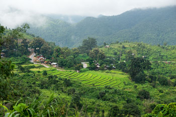
Kalaw
Another cool and pleasant hill station at the elevation of approximately 4000 feet. This is a very nice and quiet town and the starting point for many treks into the ethnic villages around the peaks surrounding the town.
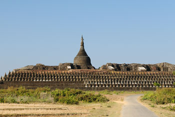
Mrauk U
The ancient capital of the last Rakhine Kingdom is situated about 50 miles from the mouth of the Kaladan River. It is accessible by boat from Sittwe. Mrauk Oo was founded in 1433 A.D by King Minsawmun and fell to enemy forces in 1784 A.D. There are many ancient and ruined pagodas in and around the old city perimeter. Going up the river some Chin villages can be reached where the women still tattoo their faces.
